Footpaths
Interactive Map


The above map shows all Public Footpaths and Bridleways that start or end within Souldern (including those that just start at the Parish Boundary).
Any problems with access to these Rights of Way may be reported to Beth Rutterford, who is the County Area Field Officer for North East Oxfordshire. Any non urgent reports are best submitted by creating a login account and selecting the Report a Problem menu item on the Countryside Access Map on the County Council website.
Alternatively, for Rights of Way within Souldern, (numbered 351/ 1 to 23) any queries of a non urgent or serious nature may be addressed to Katy Draper, who is the Parish Path Warden for Souldern.
Problems for paths in Northamptonshire may be reported via a form on the Northamptonshire county council site.
Path Descriptions
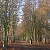 nbw/1 Nancy Bowles Wood
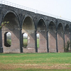 351/1 Souldern Viaduct
-
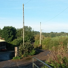 351/2 Wharf Farm to Clifton
 -
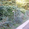 351/3 AB8 Hackertys Way
 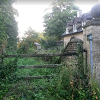 351/4 AB12 Chadwell to Upper Aynho Grounds
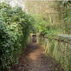 351/5 AB5 Aynho Via Souldern Church
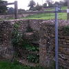 351/6 Church Lane to B4100
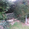 351/7 Foxhill Lane to Crown Cottage
 351/8 Foxhill Lane to Fritwell Road
 351/10 349/2 Upper Souldern Grounds to Somerton
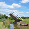 351/11 Lifting Bridge
 351/12(a) The Green to M40
 351/12(b) Upper Souldern Grounds to Somerton Road
 351/13 Foxhill Lane bridleway
 351/14 AB7 Aynho Via Souldern Mill
 351/16 B4100 to Croughton
 351/17 Wharf Lane to The Green
 351/18 Wharf Lane to Souldern Grounds Lane
 351/19 Canal Towpath
 351/20 Wharf Lane to Parish boundary
 351/21 The Tchure
 351/23 Fox Lane to Foxhill Lane bridleway
 AB9 Souldern Mill to Aynho Wharf
 219/2 Somerton Road to Heyford
-
 219/3 Hill House to Fritwell
  219/4 Somerton Road to Fritwell
 367/15 B4100 to Tusmore
 whl-1 Wharf Lane
Additional Path Descriptions
Additional routes not in the above map as they are not footpaths, or not within the Parish, but listed here as they connect with many of the above footpaths.
- AB12 AB6 Croughton via Upper Aynho Grounds
- Towpath past Somerton
- Fritwell Road
- Somerton Road
- Tusmore Road
- Roundhill Farm to A43
Definitive Footpath Maps
The above map is based on an Open Streetmap mapping with additional footpaths, and interactive representation of the footpaths added. Every care has been taken to be accurate, but it should not be taken as an authoritative representation of rights of way. Definitive footpath maps are held by each county. Oxfordshire makes its maps available on the web, Northamptonshire does not but information is provided as below.